
Using Drones to Monitor Broad-Leaved Orchids in High-Nature-Value Grassland
8_9
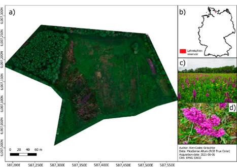
(a) Overview of the Lehmkuhlen reservoir; (b) location of the study area in Germany; (c) photograph illustrating the abundance of Dactylorhiza majalis during drone flight; (d) close-up picture of a Dactylorhiza majalis inflorescence.
| Title | Using Drones to Monitor Broad-Leaved Orchids in High-Nature-Value Grassland |
|---|---|
| Short description of the practice | Drone-based monitoring of orchids using multispectral imagery and a new magenta vegetation index provides accurate, efficient biodiversity monitoring. |
| Keywords | biodiversity conservation, indicator species, orchids, drones, vegetation index, remote sensing |
| Organisation in charge of the good practice | Earth Observation and Modelling, Department of Geography, Kiel University (Germany) |
| Implementation level of the practice | Level: Regional/National Country: Germany Region: Schleswig-Holstein (Lehmkuhlen reservoir) City: Kiel (institutional base) |
| Website | https://doi.org/10.3390/drones6070174?utm_source=chatgpt.com |
| Detailed information on the practice | Conservationists need reliable monitoring of Dactylorhiza majalis, an endangered orchid and habitat-quality indicator. Conventional field surveys are labor-intensive and error-prone. This practice introduces a drone-based monitoring approach with ~3 cm resolution imagery, combined with the new magenta vegetation index (MaVI) to detect magenta-colored orchid flowers. The method integrates MaVI with a random forest classifier, applies SHAP for feature importance, and uses object-level filtering to reduce misclassifications. Validation against field counts showed reliable results within the error margins of expert surveys. Stakeholders include Kiel University, conservation agencies, and local land managers. Beneficiaries are conservation programs and policy makers monitoring habitat restoration success. |
| Timeframe | Study conducted in July 2021; methodology can be repeated annually for long-term monitoring. |
| Approximate cost | Not explicitly reported. Costs involve drone flights, multispectral imaging, and analysis software, but are significantly lower than repeated intensive field surveys. |
| Results achieved | Drone surveys achieved an F1 score of 0.99 in detecting orchids. With filtering, the RMSE was reduced to 12 individuals/m², within expert field survey error margins. The method provides both abundance and detailed spatial distribution data. |
| Potential for learning or transfer | This practice demonstrates how drone-based remote sensing can complement or replace traditional monitoring of indicator species. Transferable to other rare or spectrally distinct flowering plants. Offers scalable, reproducible, non-invasive monitoring, reducing disturbance to fragile habitats. Potential applications in broader biodiversity monitoring, agriculture, and habitat management. |
| Additional material | Full open-access article: Gröschler, K.-C.; Oppelt, N. (2022). Using Drones to Monitor Broad-Leaved Orchids (Dactylorhiza majalis) in High-Nature-Value Grassland. Drones 6(7):174. |
| Contact person | Name: Kim-Cedric Gröschler Affiliation: Department of Geography, Kiel University Email: groeschler@geographie.uni-kiel.de |