| Short description of the practice |
Low-cost UAV imagery during leaf phenology transitions enables accurate mapping of tree species in species-rich montane forests. |
| Keywords |
tree species classification, UAV remote sensing, montane forests, phenology, biodiversity monitoring, machine learning |
| Organisation in charge of the good practice |
Center for Global Change and Complex Ecosystems, East China Normal University, Shanghai, China |
| Implementation level of the practice |
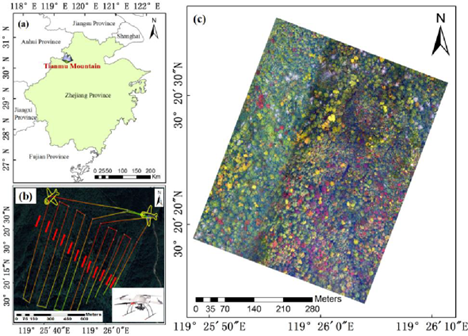
Level : Regional Country : China Region : Zhejiang Province (Tianmu Mountain National Nature Reserve) City : Shanghai (institutional base) |
| Website |
https://doi.org/10.3390/f14050908?utm_source=chatgpt.com |
| Detailed information on the practice |
The study addresses the challenge of mapping tree species in subtropical montane forests, where complex topography and biodiversity make field surveys difficult. UAV remote sensing was applied at Tianmu Mountain National Nature Reserve to classify six tree species, standing dead trees, and canopy gaps. Imagery was collected during the leaf senescence period, when spectral differences among species are strongest. Spectral, spatial, and textural features were extracted, and four classification algorithms (KNN, CART, SVM, RF) were tested. Findings: ● UAV RGB imagery during phenological transitions significantly improves classification accuracy. ● Spectral features were most important; textural features contributed little except for coniferous species. ● Topographic heterogeneity affected results: steeper areas achieved higher classification accuracy. ● The best performance (83.3% overall accuracy) was achieved with KNN using spectral and geometric features. Stakeholders: East China Normal University, Chinese Academy of Sciences, Tianmu Mountain Reserve managers. Beneficiaries: biodiversity conservation efforts, reserve managers, ecological researchers. |
| Timeframe |
UAV imagery collected: October 2017 ; field surveys conducted in 2018. Method applicable for ongoing monitoring. |
| Approximate cost |
Not specified. Requires UAV platform (MD4-1000), RGB camera, field surveys, and software (Pix4D, eCognition). Lower cost than hyperspectral or satellite monitoring. |
| Results achieved |
Overall classification accuracy reached 83.3% (KNN). Species with distinct senescence colors (Liquidambar, Ginkgo) achieved >90% accuracy. Habitat-specific classification further improved accuracy (up to 92.6% in low slopes). |
| Potential for learning or transfer |
This practice demonstrates that leaf phenology transitions offer unique spectral windows for species mapping. Transferable to other mountainous and species-rich ecosystems where biodiversity monitoring is constrained by terrain. Shows how low-cost UAV imagery can complement or replace expensive hyperspectral approaches, provided that timing (phenophase) and sufficient ground samples are ensured. |
| Additional material |
Full article : Jiang, M. et al. (2023). Seeing Trees from Drones: The Role of Leaf Phenology Transition in Mapping Species Distribution in Species-Rich Montane Forests. Forests 14(5):908. |
| Contact person |
Name: Jian Zhang Affiliation: East China Normal University, School of Ecological and Environmental Sciences Email: jzhang@des.ecnu.edu.cn |