| Short description: |
monitoring, invasive species, native flora, weed management, biodiversity, adaptive management |
| Keywords: |
|
| Organisation in charge: |
NSW Department of Planning, Industry and Environment (DPIE), Environment, Energy and Science Division |
| In collaboration with: |
|
| Implementation level: |
National / Regional |
| Country: |
Australia |
| Region: |
New South Wales |
| City: |
Sydney / Wollongong (contributors) |
| Website: |
https://www.environment.nsw.gov.au/?utm_source=chatgpt.com |
| Detailed information on the practice: |
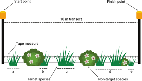
The manual provides comprehensive methods for monitoring the effects of weed control and the response of native plants and ecological communities. Monitoring is critical for adaptive land management, biodiversity conservation, and compliance with legislative frameworks such as the NSW Biodiversity Conservation Act 2016, Biosecurity Act 2015, and Local Land Services Act 2013. It introduces a two-tiered approach: ● Preliminary observations: simple mapping, cover estimates, photopoints, and documenting control activities. ● Advanced outcomes: rigorous sampling techniques (transects, quadrats, T-square) with indices of abundance, demographic Good practice template | 2 / 2 measures, and response assessments. The manual explains how to define objectives, select species, determine monitoring frequency/duration, map infestations, estimate cover/density, and record ecological data. It provides standardized datasheets for consistency and emphasizes adaptive management. Stakeholders: NSW DPIE, Centre for Sustainable Ecosystem Solutions (University of Wollongong). Beneficiaries: land managers, local councils, conservation groups, policymakers. |
| Problem & context: |
|
| Timeframe: |
Designed for ongoing monitoring programs. Preliminary methods can be applied immediately; advanced sampling suitable for long-term (3+ years) monitoring. |
| Approximate cost: |
Varies with method. Preliminary monitoring (maps, photopoints) is low-cost. Advanced methods require more labor, training, and equipment (GPS, GIS software, quadrats, transects). |
| Results achieved: |
Provides standardized, repeatable methods now adopted across NSW weed and biodiversity programs. Improves comparability of results and supports state and national datasets. |
| Potential for learning or transfer: |
This manual is a transferable framework for weed and flora monitoring in other regions. It balances cost-effectiveness with scientific rigor and allows stakeholders to adapt methods to capacity. The staged approach to weed control and standardized density classes (WoNS protocols) enhance transferability across Australia and internationally. |
| Additional material: |
Full manual: Watson GM, French KO, Burley AL, Brading MB, Hamilton MA (2021). Monitoring Manual for Invasive and Native Flora: Guidance for field monitoring and reporting. NSW DPIE. ISBN 978-1-922767-05-9. |
| Contact person: |
Georgia M. Watson |
| Contact affiliation: |
Centre for Sustainable Ecosystem Solutions, University of Wollongong / NSW DPIE |
| Contact email: |
info@environment.nsw.gov.au |