| Short description of the practice |
Drone imagery and two-step Random Forest models quantify wildflower abundance, diversity, and phenology in montane ecosystems. |
| Keywords |
floral resources, UAVs, random forest, biodiversity monitoring, montane ecosystems, machine learning |
| Organisation in charge of the good practice |
US Department of Agriculture – Agricultural Research Service (Forage & Range Research Laboratory; Pollinating Insect-Biology, Management, Systematics Research) Utah State University, Department of Biology |
| Implementation level of the practice |
Level: Regional/National Country: United States Region: Northern Utah, Bear River Mountain Range City: Logan, Utah |
| Website |
https://doi.org/10.1016/j.rama.2024.06.016?utm_source=chatgpt.com |
| Detailed information on the practice |
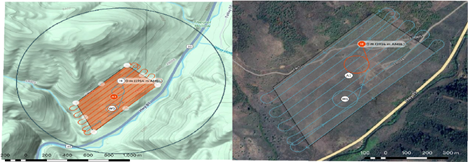
Quantifying floral resources in wildlands is essential for biodiversity monitoring but traditional field surveys are costly and limited in spatial scope. This study developed a UAV-based, two-step Random Forest classification framework to map floral resources across montane landscapes in northern Utah. Three field sites in the Bear River Range (Blacksmith Fork, Franklin Basin, Twin Creek) were surveyed with a WingtraOne UAV and RGB camera during four flights in summer 2021. Training data were collected via ground surveys, GPS points, and photographs of seven focal wildflower species. Orthomosaics (1 cm resolution) were processed with vegetation indices and texture covariates, and models were trained to classify flowers versus non-flowering vegetation/soil, then subdivide into individual species. Stakeholders: USDA-ARS, Utah State University. Beneficiaries: land managers, beekeepers, ecologists, biodiversity researchers. |
| Timeframe |
Field surveys and UAV flights: June–August 2021. Methodology scalable for seasonal and long-term monitoring. |
| Approximate cost |
Not specified. Requires UAV platform (WingtraOne), high-resolution camera, computing resources, and field survey effort. |
| Results achieved |
Seven species mapped, covering 2,138 m² (0.048% of study area). Combined flower class: sensitivity 0.77, specificity 0.99. Most species achieved >0.90 sensitivity/specificity. Blacksmith Fork had highest floral abundance (954 m²). |
| Potential for learning or transfer |
Demonstrates feasibility of UAVs and machine learning to monitor rare floral resources in complex landscapes. Transferable to other wildland ecosystems where floral phenology and pollinator resources are important. Provides high-resolution, time-series data for biodiversity monitoring and adaptive management. |
| Additional material |
Full article: Tabor, J., Hernandez, A., Cox-Foster, D., Love, B.G., McCabe, L.M., Robbins, M., Koch, J.B.U. (2025). Mapping Floral Resources in Montane Landscapes Using Unmanned Aerial Systems and Two-step Random Forest Classifications. Rangeland Ecology & Management, 98: 223–236. |
| Contact person |
Name: Alexander Hernandez Affiliation: USDA–ARS, Forage & Range Research Laboratory Email: alexander.hernandez@usda.gov |