| Short description of the practice |
Drone-based deep learning enables accurate flower abundance mapping in grasslands, reducing manual labor while supporting biodiversity monitoring. |
| Keywords |
Drones, grasslands, deep learning, biodiversity monitoring, flower mapping, UAV |
| Organisation in charge of the good practice |
ETH Zürich (Department of Computer Science, Department of Agricultural Sciences) and Agroscope (Agricultural Landscape and Biodiversity Group, Remote Sensing Team) |
| Implementation level of the practice |
Level : Regional/National Country : Switzerland Region : Zurich and test sites in Swiss grasslands City : Zurich |
| Website |
https://doi.org/10.3389/fpls.2021.774965?utm_source=chatgpt.com |
| Detailed information on the practice |
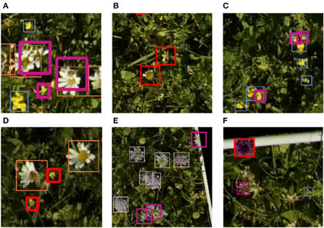
Manual counting of flowers in biodiversity studies is time-consuming and error-prone. This practice introduces a drone-based, deep-learning pipeline (Faster R-CNN) to automatically detect and count flowers in grasslands from ultra-high-resolution aerial imagery (~1.5 mm/pixel). The approach used drones equipped with high-resolution cameras, annotated training datasets (10,000 flowers, 40 species), and ground control points for georeferencing. Data were annotated via a custom Android app, and models were trained with data augmentation to handle variability. Results showed that the model could reliably detect dominant species (Leucanthemum vulgare, Knautia arvensis, Lotus corniculatus) with precision and recall above 85–95%. More challenging species with few samples or low contrast performed less well. Stakeholders : ETH Zürich, Agroscope, Swiss National Science Foundation. Beneficiaries: ecologists, conservationists, land managers, and biodiversity monitoring programs. |
| Timeframe |
Fieldwork: May–July 2019 (multi-temporal flights across 5 days). The method is scalable for repeated seasonal monitoring. |
| Approximate cost |
Not specified; requires drones, high-resolution cameras, annotation tools, and computational resources for training deep learning models. |
| Results achieved |
Overall performance : 87% precision, 84% recall, F1 score 0.855. For key species, drone-based predictions matched manual extrapolations within 2–11%. The method generated spatially explicit flower maps and temporal dynamics. |
| Potential for learning or transfer |
This practice demonstrates how combining drones with deep learning can revolutionize biodiversity monitoring. Transferable to other habitats, species, or ecological applications (weed detection, invasive species monitoring, pollinator habitat assessment). Provides scalable, less labor-intensive, and more spatially explicit results than manual surveys. Challenges include limited training data for rare species and difficulties with very small or faded flowers. |
| Additional material |
Full article : Gallmann, J. et al. (2022). Flower Mapping in Grasslands With Drones and Deep Learning. Frontiers in Plant Science 12:774965. |
| Contact person |
Name: Dr. Helge Aasen Affiliation: Agroscope / ETH Zürich Email: science@helgeaasen.net |